Chapter Overview:
India is one of the ancient civilisations in the world. This chapter covers India's precise location on
the globe (Latitude, Longitude), its size compared to the world, its standard meridian, and its
neighbours.
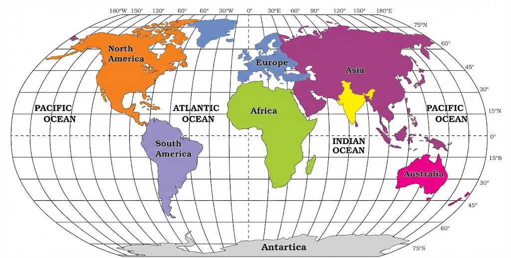
Figure 1.1: Location of
India in the World
1. Location
India is a vast country lying entirely in the Northern Hemisphere.
- Latitudinal Extent: 8°4'N to 37°6'N (Distance of approx 3,214 km from North to South).
- Longitudinal Extent: 68°7'E to 97°25'E (Distance of approx 2,933 km from East to West).
- Tropic of Cancer (23°30'N): Divides the country into almost two equal parts. Passes
through states like Gujarat, Rajasthan, MP, Chhattisgarh, Jharkhand, West Bengal, Tripura, Mizoram.
- Islands:
- Andaman and Nicobar Islands: Southeast of mainland in Bay of Bengal.
- Lakshadweep Islands: Southwest of mainland in Arabian Sea.
Concept: Duration of Day and Night
Why is the difference between the durations of day and night hardly felt at Kanyakumari but not
so in Kashmir?
- Kanyakumari is near the equator, so day and night are almost equal (approx 12 hours each) throughout
the year.
- Kashmir is far from the equator (high latitude), so the difference between day and night duration is
more significant (longer days in summer, shorter in winter).
The southernmost point of the Indian Union, 'Indira Point', got submerged under the sea water in 2004
during the Tsunami. It was located in the Andaman and Nicobar Islands.
2. Size
India has a prominent distinct geographical entity.
- Total Area: 3.28 million sq. km.
- Global Share: India's total area accounts for 2.4%
of total geographical area of the world.
- Rank: India is the 7th largest country in the world.
- Land Boundary: Approx 15,200 km.
- Coastline (including islands): 7,516.6 km.
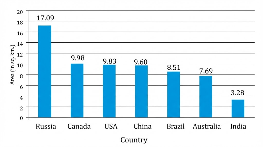
Figure 1.2: Seven Largest
Countries of the World

Figure 1.3: India - Extent
and Standard Meridian
3. India and the World
Strategic Location:
- India is centrally located between East and West Asia.
- The Deccan Peninsula protrudes into the Indian Ocean, helping establish close
contact with West Asia, Africa and Europe from western coast and with South-East and East Asia from
eastern coast.
- This central location helps in trade and cultural exchange.
Exchange of Ideas and Commodities:
- Ideas: The ideas of the Upanishads and the
Ramayana, the stories of Panchtantra, the Indian
numerals and the decimal system reached many parts of the world.
- Commodities: Spices, muslin, and other merchandise were taken from India to
different countries.
- Architecture: Influence of Greek sculpture, and the architectural styles of dome
and minarets from West Asia can be seen in India.
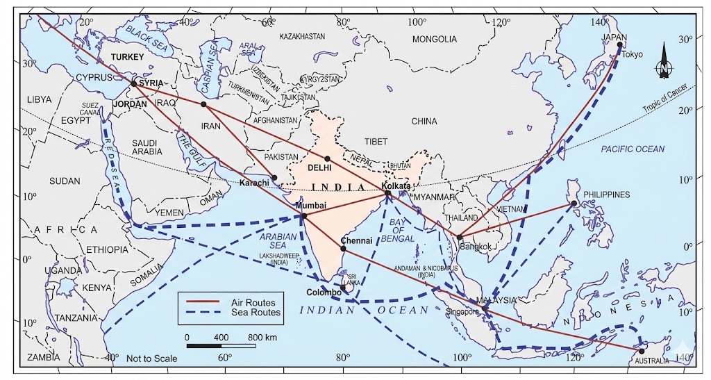
India on International
Highway of Trade
Suez Canal (1869): Since the opening of the Suez Canal in 1869, India's distance from
Europe has been reduced by 7,000 km. Ships no longer have to sail around Africa.
4. Standard Meridian of India
Why do we need a Standard Meridian?
- From Gujarat to Arunachal Pradesh, there is a time lag of 2 hours.
- Because 1 degree longitude = 4 minutes time difference. approx 30 degrees difference x 4 = 120 mins
= 2 hours.
- To maintain a uniform time for the whole country, the time along the Standard Meridian of
India (82°30'E) passing through Mirzapur (Uttar Pradesh) is taken as
the standard time for the whole country.
5. India's Neighbours
India has 28 States and 8 Union Territories. It shares its land boundaries with:
- North-West: Pakistan and Afghanistan.
- North: China (Tibet), Nepal and Bhutan.
- East: Myanmar and Bangladesh.
- South (Island neighbours):
- Sri Lanka: Separated from India by a narrow channel of sea formed by the
Palk
Strait and the Gulf of Mannar.
- Maldives: Situated to the south of the Lakshadweep Islands.
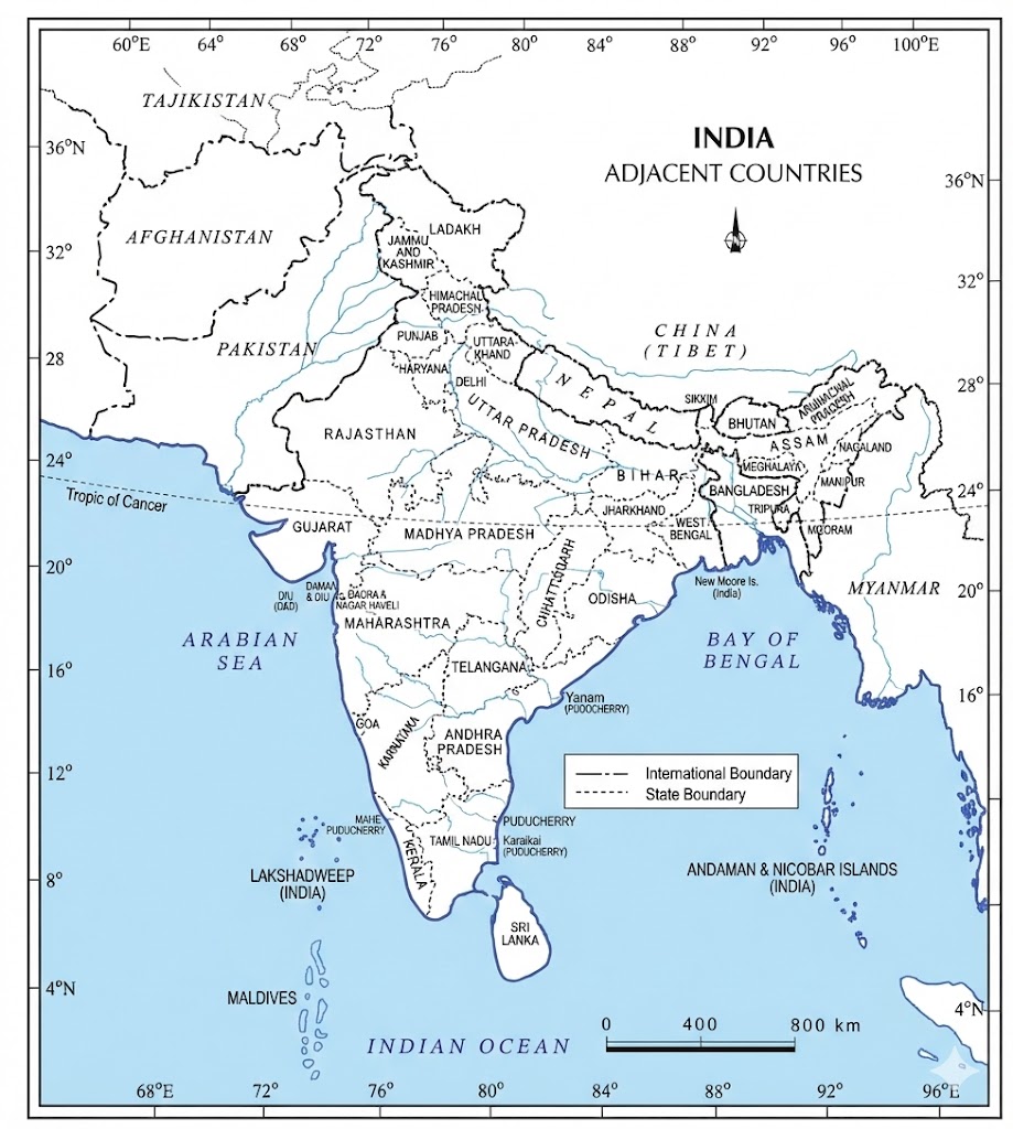
India and Adjacent
Countries
Q1: Which canal reduced the distance between India and Europe?
Ans: The Suez Canal (Opened in 1869).
Q2: Name the states through which the Tropic of Cancer passes.
Ans: Gujarat, Rajasthan, Madhya Pradesh, Chhattisgarh, Jharkhand, West Bengal, Tripura,
and Mizoram.