Chapter Overview:
India consists of vast plains, rugged mountains, deserts, and plateaus. This chapter explains the
formation of these features through Tectonic plates and details the six physiographic divisions of
India.
1. Theory of Plate Tectonics
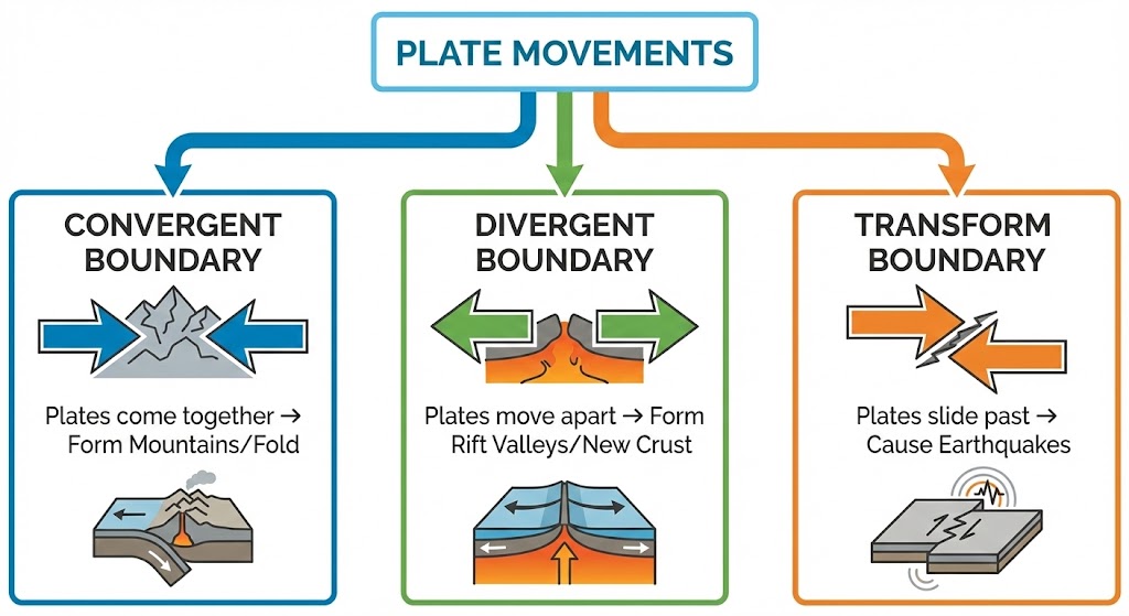
The crust is broken into 7 major and some minor plates. Movement results in:
- Convergent Boundary: Plates move towards each other (Form Mountains like
Himalayas).
- Divergent Boundary: Plates move away (Form Rift Valleys).
- Transform Boundary: Plates slide horizontally (Causes Earthquakes).
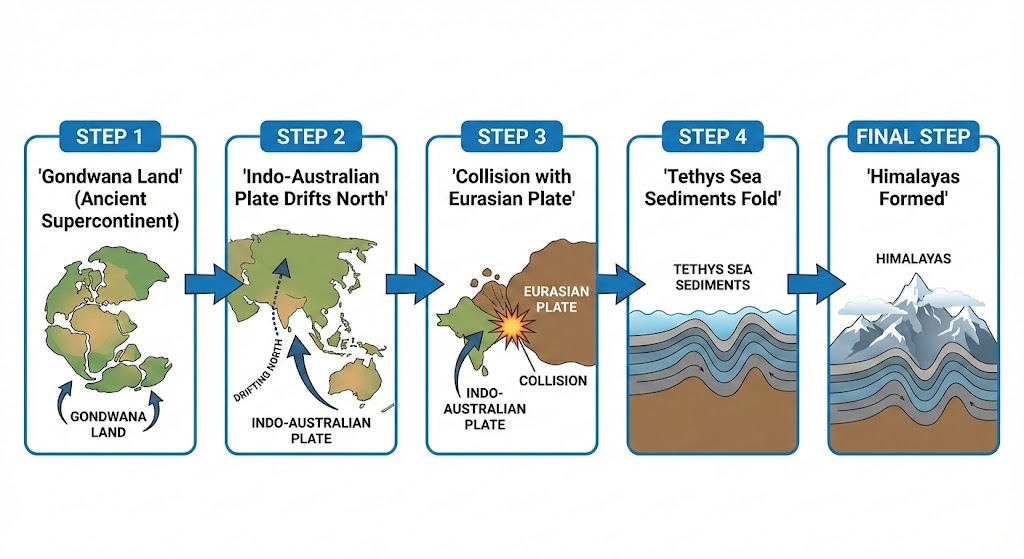
Formation of Himalayas:
- Original landmass was Gondwana Land (India, Australia, South Africa, South America,
Antarctica).
- The Indo-Australian plate drifted North and collided with the much larger Eurasian
Plate.
- This collision folded the sedimentary rocks of the **Tethys Sea**, forming the mountain system of
western Asia and the Himalayas.
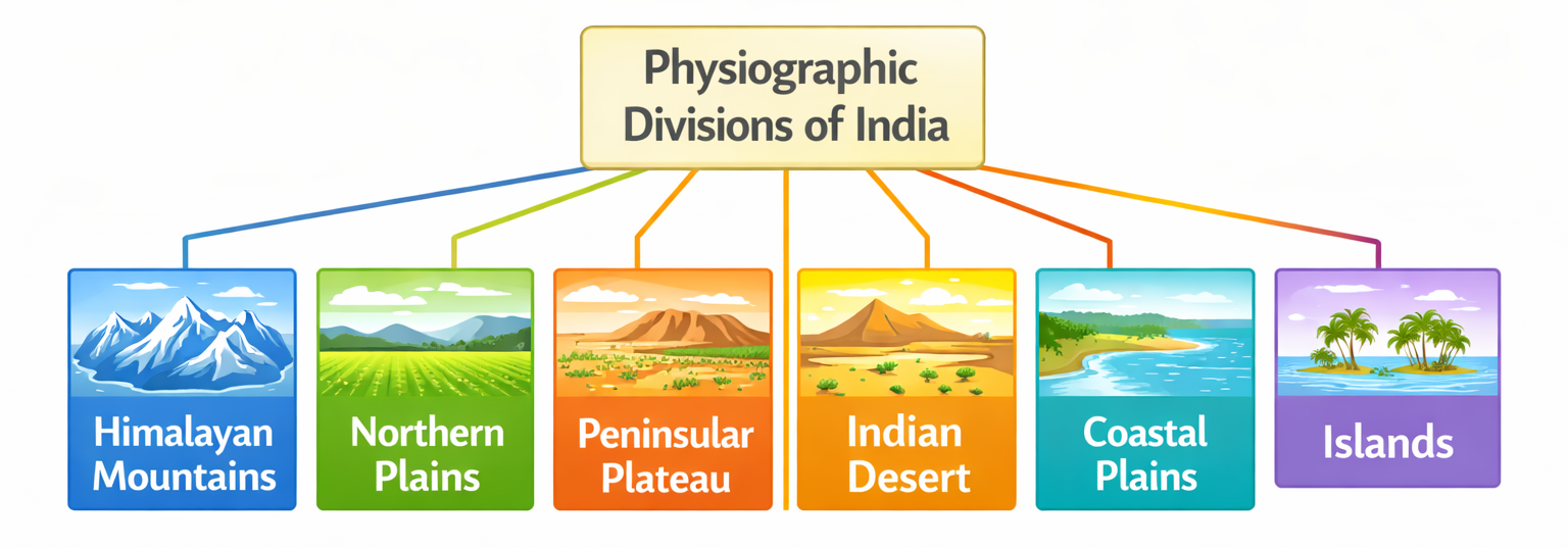
2. Major Physiographic Divisions
(i) The Himalayan Mountains
Young fold mountains stretching from Indus to Brahmaputra (2400 km long). Width varies from 400 km in Kashmir
to 150 km in Arunachal Pradesh.
Longitudinal Division (Parallel Ranges):
- Himadri (Great Himalayas): Northernmost, highest (Avg 6000m). Perennial snow.
Important Peaks: Mt. Everest (8848m, Nepal),
Kanchenjunga (8586m, India), Makalu (8481m, Nepal),
Dhaulagiri (8172m, Nepal), Nanga Parbat (8126m, India).
- Himachal (Lesser Himalayas): Avg height 3700-4500m. Famous for Hill stations
(Shimla, Mussoorie, Nainital) and Valleys (Kullu, Kangra, Kashmir). Ranges: Pir Panjal (longest),
Dhaula Dhar.
- Shiwaliks (Outer Himalayas): Southernmost, width 10-50 km, height 900-1100m. Made
of unconsolidated sediments. Valleys between Himachal and Shiwaliks are called Duns
(Dehra Dun, Patli Dun).

The Purvanchal Hills (Eastern Hills):
Beyond the Dihang gorge, the Himalayas bend sharply to the south and spread along the eastern boundary of
India.
- Composed of strong sandstones (sedimentary rocks).
- Covered with dense forests.
- Comprise the Patkai Hills, Naga Hills, Manipur Hills, and Mizo Hills.
Regional Divisions (West to East):
- Punjab Himalayas: Between Indus and Satluj.
- Kumaon Himalayas: Between Satluj and Kali.
- Nepal Himalayas: Between Kali and Tista.
- Assam Himalayas: Between Tista and Dihang.
Kumaon Himalayas: Between Satluj and Kali.
Nepal Himalayas: Between Kali and Tista.
Assam Himalayas: Between Tista and Dihang.
(ii) The Northern Plains
Formed by the interplay of the three major river systems: the Indus, the Ganga and the
Brahmaputra along with their tributaries. This vast plain is formed of alluvial soil. It is
densely
populated and agriculturally very productive.
Sections of Northern Plains:
- Punjab Plains: Western part. Formed by Indus and its tributaries (Jhelum, Chenab,
Ravi,
Beas, Satluj). Larger part lies in Pakistan. Dominated by Doabs (land between two rivers).
- Ganga Plains: Extends between Ghaggar and Teesta rivers. Covers states like
Haryana,
Delhi, UP, Bihar, partly Jharkhand and West Bengal.
- Brahmaputra Plains: Lies in the east, particularly in Assam.
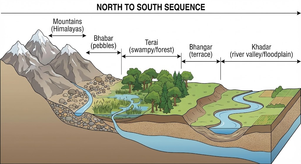
Relief Features (North to South):
- Bhabar: Narrow belt (8-16 km) parallel to Shiwaliks. Rivers deposit pebbles here.
Streams disappear in this belt.
- Terai: South of Bhabar. Wet, swampy, marshy region. Streams re-emerge here.
Thickly forested and full of wildlife.
- Bhangar: Largest part of the northern plain. Formed of older alluvium.
Liies above flood plains of rivers and presents a terrace-like feature. Contains calcareous deposits
locally
known as Kankar.
- Khadar: Newer, younger deposits of the floodplains. Renewed almost every year. Very
fertile, thus ideal for intensive agriculture.
(iii) The Peninsular Plateau
A tableland composed of the old crystalline, igneous, and metamorphic rocks. It was formed due to the
breaking
and drifting of the Gondwana land.
Two Broad Divisions:
- Central Highlands: Lying to the north of the Narmada river, covering a major area
of
the Malwa plateau.
- Vindhya range is bounded by the Satpura range on the south and the Aravallis on the
northwest.
- Rivers (Chambal, Sind, Betwa, Ken) flow from southwest to northeast (indicating slope).
- Bundelkhand and Baghelkhand are the eastward extensions.
- Chotanagpur Plateau marks the further eastward extension, drained by the
Damodar river.
- Deccan Plateau: A triangular landmass that lies to the south of the river Narmada.
- Satpura range flanks its broad base in the north.
- Mahadev, Kaimur hills and Maikal range form its eastern extensions.
- Higher in the west and slopes gently eastwards.
- Extensions in Northeast: Meghalaya, Karbi-Anglong Plateau, and North Cachar
Hills. Separated by a fault (Malda gap) from the Chotanagpur Plateau.
- Deccan Trap: The distinct feature of the Peninsular plateau is the black
soil
area of volcanic origin. Rocks are igneous.
| Western Ghats |
Eastern Ghats |
| Continuous, crossed only through passes (Thal, Bhor, Pal Ghats). |
Discontinuous, dissected by rivers draining into Bay of Bengal. |
| Higher (Avg 900-1600m). |
Lower (Avg 600m). |
| Highest Peak: Anamudi (2,695m). |
Highest Peak: Mahendragiri (1,501m). |
| Cause orographic rain. |
Rainfall involves cyclones during retreating monsoon. |

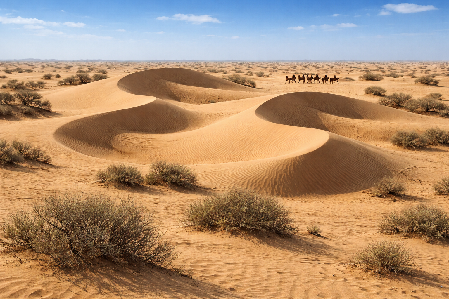
(iv) The Indian Desert
Lies towards the western margins of the Aravalli Hills. It is an undulating sandy plain covered with sand
dunes.
- Receives very low rainfall (below 150 mm per year) because the Aravalli Hills lie
parallel to the moisture-bearing winds, failing to stop them to cause rain.
- Arid climate with low vegetation cover.
- Luni is the only large river in this region.
- Barchans: Crescent-shaped dunes. Cover larger areas, but longitudinal dunes become more
prominent near the Indo-Pakistan boundary.
(v) The Coastal Plains
- Western Coast: Narrow plain between Western Ghats and Arabian Sea.
- Konkan: Northern part (Mumbai-Goa).
- Kannad Plain: Central part.
- Malabar Coast: Southern stretch.
- Eastern Coast: Wide and level, along Bay of Bengal.
- Northern Circar: Northern part.
- Coromandel Coast: Southern part.
- Deltas: Mahanadi, Godavari, Krishna, Kaveri form extensive deltas here.
Lake Chilika is an important feature.
(vi) The Islands
💡 Corals: Short-lived microscopic organisms, which live in colonies. They flourish in
shallow, mud-free, and warm waters. They secrete calcium carbonate. The coral secretion and their
skeletons form massive coral deposits (e.g., Barrier Reef, Fringing Reef, Atolls).
- Lakshadweep Islands:
- Lying close to the Malabar coast of Kerala.
- Composed of small coral islands. Previously known as Laccadive, Minicoy, and Amindive.
Renamed
in 1973.
- Small area of 32 sq km.
- Kavaratti island is the administrative headquarters.
- Pitti Island (uninhabited) has a bird sanctuary.
- Andaman and Nicobar Islands:
- Elongated chain of islands located in the Bay of Bengal extending from north to south.
- Bigger in size and are more numerous and scattered.
- Divided into two broad categories: The Andaman in the north and the
Nicobar in the south.
- Separated by the Ten Degree Channel.
- Believed to be elevated portions of submarine mountains.
- Great strategic importance. Equatorial climate. Thick forest cover.
- Barren Island is India's only active volcano.
Q1: Which is the highest peak in the Eastern Ghats?
Ans: Mahendragiri (1501 metres).
Q2: What are Barchans?
Ans: Barchans are crescent-shaped sand dunes found in the Indian Desert.