Chapter Overview:
The term 'drainage' describes the river system of an area. This chapter explores the major drainage
systems of India—the Himalayan and the Peninsular rivers—along with lakes and the role of rivers in the
economy.
1. Introduction to Drainage
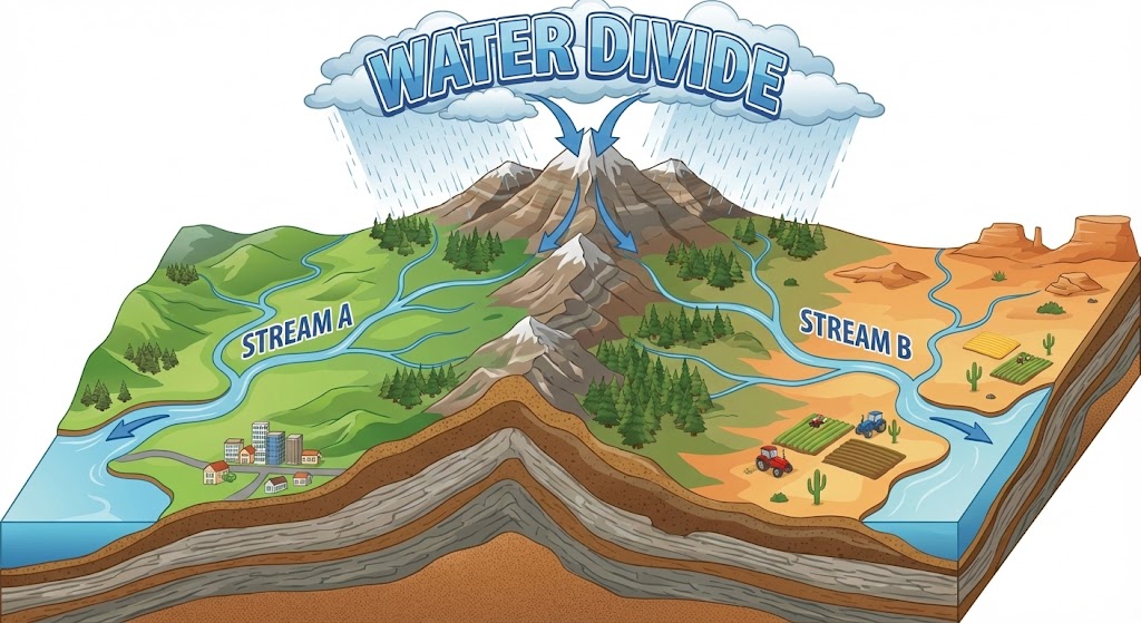
- Drainage Basin: The area drained by a single river system is called a drainage
basin.
- Water Divide: Any elevated area, such as a mountain or an upland, that separates
two drainage basins (e.g., Ambala separates Indus and Ganga basins).
2. Drainage Systems in India
The drainage systems of India are mainly controlled by the broad relief features of the subcontinent.
Accordingly, the Indian rivers are divided into two major groups:
- The Himalayan Rivers
- The Peninsular Rivers
Comparison: Himalayan vs Peninsular Rivers
| Feature |
Himalayan Rivers |
Peninsular Rivers |
| Nature |
Perennial (water throughout the year from rain + snow). |
Seasonal (dependent on rainfall). |
| Course |
Long courses, perform intensive erosion. |
Shorter and shallower courses. |
| Features |
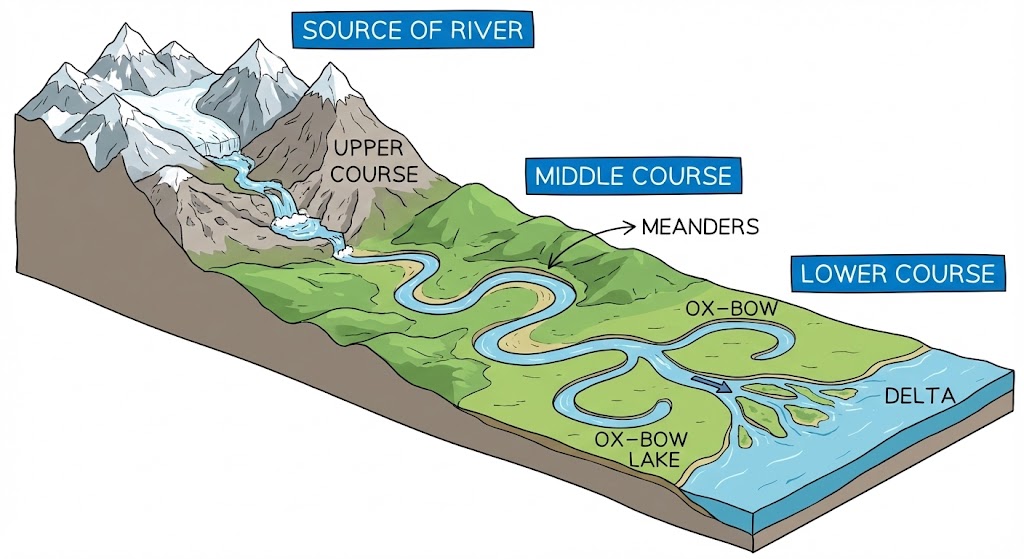
Form gorges, meanders, ox-bow lakes, and deltas. |
Flow through rift valleys (some) or form deltas. |
3. The Himalayan Rivers
The major Himalayan rivers are the Indus, the Ganga, and the
Brahmaputra.
(i) The Indus River System
- Origin: Near Lake Mansarovar in Tibet.
- Course: Enters India in Ladakh. Tributaries like Zaskar, Nubra, Shyok, and Hunza join
it in Kashmir.
- Major Tributaries: Satluj, Beas, Ravi, Chenab, and Jhelum join together to enter the
Indus near Mithankot in Pakistan.
- End: Flows southwards and drains into the Arabian Sea east of Karachi.
- Length: 2900 km (One of the longest rivers).
- Indus Water Treaty (1960): India can use only 20% of the total water carried by the
Indus river system. Used for irrigation in Punjab, Haryana, and Rajasthan.
(ii) The Ganga River System
- Headwaters: The headwaters called the Bhagirathi is fed by the
Gangotri Glacier and joined by the Alaknanda at Devaprayag in
Uttarakhand to form the Ganga.
- Course: At Haridwar, the Ganga emerges from the mountains on to the plains.
- Tributaries:
- Himalayan: Yamuna (from Yamunotri), Ghaghara, Gandak, Kosi. Yamuna meets Ganga at
Allahabad.
- Peninsular Uplands: Chambal, Betwa, Son.
- Farakka Barrage: In West Bengal, the river bifurcates:
- Bhagirathi-Hooghly: Flows southwards to the Bay of Bengal.
- Main Stream: Flows into Bangladesh, joined by Brahmaputra (called
Meghna downstream).
- Delta: The Sundarban Delta (largest and fastest growing delta, home to Royal Bengal
Tiger).
- Length: Over 2500 km.
(iii) The Brahmaputra River System
- Origin: Tibet east of Mansarovar (close to sources of Indus and Satluj).
- In Tibet: Known as Tsangpo. Carries smaller volume of water and less
silt (cold and dry region).
- In India: Enters Arunachal Pradesh through a gorge (taking a 'U' turn
at Namcha Barwa). Here it is called **Dihang**. Joined by Dibang and Lohit.
- Features: Features a braided channel in Assam and forms many riverine islands (e.g.,
Majuli, largest inhabited riverine island in the world).
- Floods: Overflows banks every year causing devastation in Assam and Bangladesh but
enriching soil.
4. The Peninsular Rivers
The main water divide in Peninsular India is formed by the Western Ghats. Most rivers flow eastwards into the
Bay of Bengal. Narmada and Tapi are the only long rivers flowing west.
(i) The Narmada Basin
- Source: Amarkantak hills in Madhya Pradesh.
- Flow: Flows towards the west in a rift valley formed due to faulting.
- Features: 'Marble rocks' near Jabalpur (deep gorge) and 'Dhuadhar falls'.
- Basin: MP and Gujarat.
(ii) The Tapi Basin
- Source: Satpura ranges, in Betul district of Madhya Pradesh.
- Flow: Flows in a rift valley parallel to Narmada but is shorter.
- Basin: MP, Gujarat, Maharashtra.
(iii) The Godavari Basin (Dakshin Ganga)
- Source: Slopes of Western Ghats in Nasik district of Maharashtra.
- Size: Largest Peninsular river (Length: 1500 km). Largest drainage basin.
- Tributaries: Purna, Wardha, Pranhita, Manjra, Wainganga, Penganga.
- Reach: Drains into Bay of Bengal. Basin covers Maharashtra (50%), MP, Odisha, Andhra
Pradesh.
(iv) The Mahanadi Basin
- Source: Highlands of Chhattisgarh.
- Length: About 860 km.
- Basin: Maharashtra, Chhattisgarh, Jharkhand, Odisha.
(v) The Krishna Basin
- Source: Spring near Mahabaleshwar.
- Length: About 1400 km.
- Tributaries: Tungabhadra, Koyana, Ghatprabha, Musi, Bhima.
- Basin: Maharashtra, Karnataka, Andhra Pradesh.
(vi) The Kaveri Basin
- Source: Brahmagiri range of Western Ghats.
- Length: About 760 km.
- Tributaries: Amravati, Bhavani, Hemavati, Kabini.
- Falls: Shivanasamudra falls (2nd biggest in India).
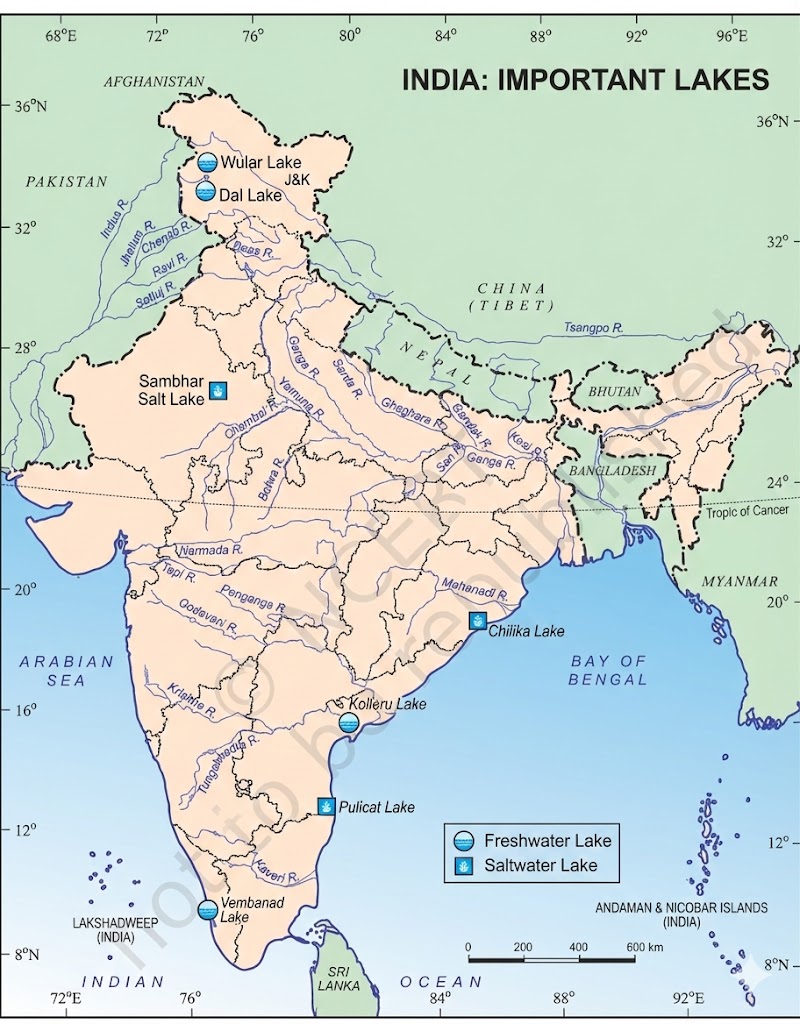
5. Lakes
Significance: Regulate river flow, prevent flooding, hydel power, enhance beauty, distinct aquatic ecosystem.
- Wular Lake (J&K): Result of tectonic activity. Largest freshwater lake in India.
- Dal Lake, Bhimtal, Nainital: Freshwater lakes.
- Sambhar Lake (Rajasthan): Salt water lake. Used for producing salt.
- Chilika (Odisha), Pulicat, Kolleru: Lagoons formed by spits and bars in coastal
areas.
- Guru Gobind Sagar: Man-made lake (Bhakra Nangal Project).
6. Role of Rivers in the Economy
- Irrigation: Essential for agriculture in a country like India.
- Navigation: Inland transport.
- Hydro-power: Generation of hydroelectricity.
7. River Pollution
Causes & Action Plans:
- Growing domestic, municipal, industrial, and agricultural demand affects water quality.
- Heavy load of untreated sewage and industrial effluents emptied into rivers.
- NRCP (National River Conservation Plan): Aims to improve water quality.
- Namami Gange: Integrated Conservation Mission for the Ganga river.
Q1: Which is the longest river of the Peninsular India?
Ans: Godavari.
Q2: Name the two headstreams of the Ganga.
Ans: Bhagirathi and Alaknanda.